TRISHNA Mission – [Thermal infraRed Imaging Satellite for High-resolution Natural resource Assessment]
| Aspect | Details |
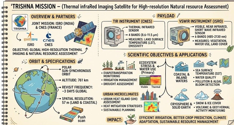
| Collaborating agencies. | ISRO (India) + CNES (France). |
|
Type |
Joint Earth observation satellite |
|
Launch timeline |
Announced for 2027 launch |
|
Launch vehicle |
Planned aboard a PSLV rocket from Satish Dhawan Space Centre |
|
Orbit |
Sun-synchronous orbit at 761 km altitude, local time 12:30 PM at equator |
|
Mission life |
5- 7 years minimum |
|
Resolution/Revisit |
57 m spatial resolution; revisit interval of about 3 days (for land/coastal areas; 1 km for oceans/polar regions. |
Payloads-
- TIR (Thermal Infra-Red) payload - provided by CNES; four-channel long-wave infrared imaging sensor for high-resolution surface temperature and emissivity mapping .
- VNIR-SWIR payload - developed by ISRO; seven spectral bands for mapping surface reflectance, generating biophysical and radiation budget variables.
Objectives/Applications
- Designed to monitor land and water resources through advanced thermal infrared imaging .
- Provides data on agriculture, water management, climate monitoring, environmental sustainability.
- Assessment of urban heat islands, thermal anomalies linked to volcanic/geothermal activity, snow-melt runoff and glacier dynamics .
- Data on aerosol optical depth, atmospheric water vapor, and cloud cover .
- Contributes to GEOGLAM (Group on Earth Observations Global Agricultural Monitoring), UN SDGs, and Global Water Watch .
- Core focus- addressing water and food security challenges.